


WinGPS™ Marine

توضیحات WinGPS™ Marine
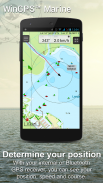
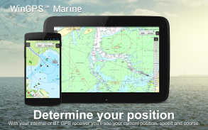
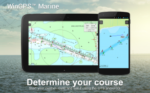
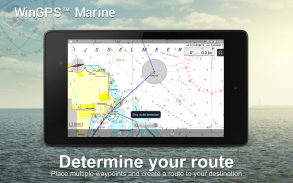
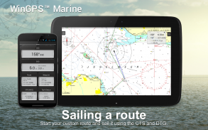
WinGPS Marine ابزارهای ناوبری مدرن و آسان برای یک سفر ایمن را به شما ارائه می دهد. برای ترسیم مسیر خود، روی نمودار به مدت طولانی فشار دهید. GPS موجود در هواپیما مکان دقیق شما را نشان می دهد. نمودارها را در دستگاه خود دانلود کنید و با به روزترین نمودارها به قایق سواری آفلاین بروید. AIS خود را از طریق WIFI وصل کنید و از برخوردهای احتمالی جلوگیری کنید.
توسط Stentec برای ناوبری در قایق های بادبانی و موتوری، شناورها و قایق ها در دریا، جزر و مد و آب های داخلی توسعه یافته است. ایده آل برای اجاره یا اجاره قایق.
• پشتیبانی از آبراه ها برای نمودارهای داخلی اروپای غربی و دوناو با اطلاعات پل، قفل و آبراه. با استفاده از این می توانید مسیرهای خود را به سرعت ترسیم و تنظیم کنید و هر گونه مانع را نشان دهید. نام آبراه ها و مسافت ها در طول سفر شما نشان داده می شود.
• برچسبگذاری هوشمند از همپوشانی برچسبهای متنی (همچنین با آبراههها) برای تصویر نمودار بهینه جلوگیری میکند. داده های پل و قفل همیشه در نمودارهای چرخشی Course Up قابل خواندن خواهند بود.
نکات برجسته
• پیمایش در نمودارهای به روز Stentec، Imray، NOAA و Delius Klasing.
• پشتیبانی از کارت SD برای ذخیره سازی نمودار.
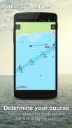
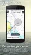
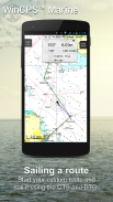
• مسیرها، نمودارها، مسیرها و ایستگاه های بین راه را مدیریت کنید.
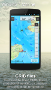
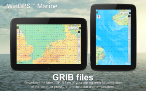
• فایل های NOAA World GRIB: باد، فشار هوا، بارندگی و دما.
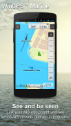
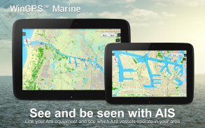
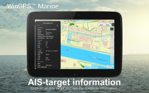
• AIS و GPS را از طریق اتصال بی سیم WIFI یا بلوتوث متصل کنید.
• از برخورد با بردارهای سرعت کشتی های AIS جلوگیری کنید.
• دکمه Man-Overboard به بازیابی خدمه گمشده کمک می کند.
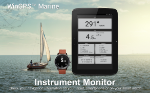
• نمودار در زیر موقعیت GPS مرکزی حرکت می کند. NorthUp، CourseUp (دریایی) یا HeadUp (Plus).
• Harmoniemodel KNMI با پیش بینی دقیق آب و هوا (به علاوه، فقط هلند)
• پیش بینی موج NOAA در دریای آزاد (به علاوه، در سراسر جهان)
هنگامی که WinGPS Marine برای اولین بار نصب می شود، این WinGPS Marine Lite با عملکردهای محدود خواهد بود. ایده آل به عنوان یک نمایشگر نمودار با پشتیبانی از GPS.
خرید درون برنامه ای
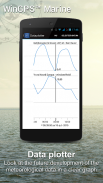
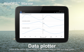
پس از نصب WinGPS Marine، تمام قابلیت های سیستم ناوبری شخصی خود را باز خواهید کرد. اکنون میتوانید مسیرها را ترسیم کنید، فایلهای GRIB را دانلود کنید، آهنگهای قبلی را ذخیره کنید و AIS و GPS را متصل کنید. از جدول زمانی مفید برای مشاهده باد، باران، فشار هوا و اهداف AIS پیش بینی شده استفاده کنید.
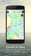
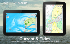
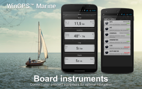
با ارتقای WinGPS Marine Plus، میتوانید ابزارهای برد اضافی را از طریق اتصال بیسیم به رایانه شخصی خود، مالتی پلکسر یا ترانسپوندر AIS متصل کنید. می توانید اطلاعات جاری و جزر و مد را در پلاتر داده خود نمایش دهید یا آن را در نمودار مشاهده کنید. همچنین، مدل پیشرفته هواشناسی هارمونی KNMI و همچنین امواج NOAA در سراسر جهان پشتیبانی می شود.
KUSTFIJN Getijmodel Rijkswaterstaat با باد دو روزه به پیش بینی جریان ها، جزر و مد و سطح آب در Waddenzee، Ijsselmeer، Markermeer، Randmeren و Zeeland بستگی داشت. خطوط قرمز عمق آبراه های ایمن را بسته به عمق، جزر و مد و انحرافات ناشی از باد محدود می کند.
پوشش نمودار و نصب نمودارها
هنگامی که WinGPS Marine را راه اندازی می کنید، به طور خودکار نمودار توپوگرافی پیش فرض (آنلاین) ESRI را خواهید دید. همچنین می توانید نمودارهای NOAA ایالات متحده را روشن کنید و نمودار جهان رایگان را از طریق Chart Manager دانلود کنید
برای ناوبری ایمن، می توانید نمودارهای دیجیتال را در www.stentec.com خریداری کنید. همچنین امکان خرید نمودارها در برنامه یا از طریق Google Play™ وجود دارد. نمودارهای شما را می توان در 3 دستگاه مختلف نصب کرد. به عنوان مثال، در تبلت، تلفن اندرویدی و لپ تاپ یا رایانه ویندوزی شما.
با حساب Stentec خود در برنامه Marine وارد شوید و نمودارهای DKW2 خریداری شده خود را در Chart Manager دانلود یا به روز کنید.
به عنوان مثال، سری محبوب DKW1800 با بهروزرسانیهای هفتگی BaZ و نمودار NL با بهروزرسانیهای دو هفتهای. فروشگاه آنلاین ما نمودارهای دریایی به روز و همه نمودارهای داخلی اروپای غربی از جمله دوناو را ارائه می دهد.
اطلاعات بیشتر:
www.wingpsmarine.com
سیاست حفظ حریم خصوصی:
www.stentec.com/en/en/privacy-statement
ورودی کاربران
برای بهبود برنامه ما بسیار علاقه مند به تجربیات و پیشنهادات شما هستیم. لطفاً یک ایمیل به helpdesk@stentec.com ارسال کنید.
WinGPS™ Marine - نسخه 4.76
(23-04-2025)
WinGPS™ Marine - اطلاعات APK
نسخه APK: 4.76حزمة: com.stentec.wingps_marine_liteآخرین نسخه WinGPS™ Marine
سایر نسخهها


 4.35
4.35


اپلیکیشنها در دسته مشابه


شاید دوست داشته باشید...


